Transportation
Learn more about Tysons existing transportation infrastructure and activity.
Trip Profile
Trip Activity
225K
Average Daily Trips to Tysons
This metric shows the total number of trips that ended in Tysons on an average weekday in Spring 2025. Source: Replica
Trip Activity
126K
People Taking Trips to Tysons
This metric shows how many individual people took any number of trips that ended in Tysons on an average weekday in Spring 2025. Source: Replica
Trip Activity
6 mi
Median Trip Distance to Tysons (miles)
This metric shows the median trip distance in miles for all trips ending in Tysons on an average weekday in Spring 2025. Source: Replica
Trip Activity
12 min
Median Trip Duration to Tysons (minutes)
This metric shows the median duration in minutes of all trips ending in Tysons on an average weekday in Spring 2025. Source: Replica
Trip Activity
Trips to Tysons by Purpose
Mode Share
Trips to Tysons by Mode Share
Walk, Bike, Roll
Biking
3K
Average Daily Bike Trips
This metric shows the number of bike trips that took place within Tysons on an average weekday in Spring 2025. Source: Replica
Biking
12K
Annual Bird Scooter Trips Starting in Tysons
This metric shows the number of Bird trips that started in Tysons in 2024. Source: Bird

Biking
22
Capital Bikeshare Stations
This metric shows the total number of Capital Bikeshare stations in Tysons. Source: Capital Bikeshare
Biking
8K
Annual Bikeshare Trips Starting in Tysons
This metric shows how many capital bikeshare trips started in Tysons in 2024. Source: Capital Bikeshare
Biking
Capital Bikeshare Use by Station (%)


Biking
Capital Bikeshare Trips by Month
Walking
57
Walkscore
Walkscore is a measure from 0 to 100 for how safe and accessible a place is by walking. A Tysons-wide aggregate walkscore was generated using an average of all walkscores for each address in the Tysons urban district boundary. Source: Walkscore.com
Biking
43
Bikescore
Bikescore is a measure from 0 to 100 for how safe and accessible a place is by bike. A Tysons-wide aggregate bikescore was generated using an average of all bikescores for each address in the Tysons urban district boundary. Source: Walkscore.com

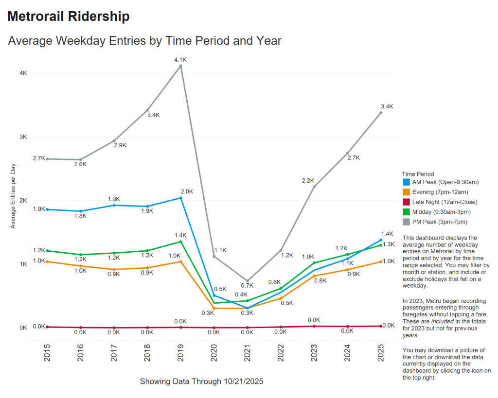
Transit
Transit
Metro Ridership
Residential
65%
Population within 1/4mi of Metro
This metric describes the percentage of the overall population of Tysons that lives within 1/4 mile of a metro station. Source: Cambridge Systematics analysis
Employment
79%
Jobs within 1/4mi of Metro
This metric describes the percentage of jobs in Tysons within a 1/4 mile of a metro station. Source: Cambridge Systematics analysis
Transit
22
Bus Routes Serving Tysons
This metric shows the number of bus routes serving Tysons (Fairfax Connector, OmniRide & Metrobus). Source: FCDOT
Transit
57
Transitscore
Transitscore is a measure from 0 to 100 for how safe and accessible a place is by public transit. A Tysons-wide aggregate Transitscore was generated using an average for all transitscores of each address in the Tysons urban district boundary Source: Walkscore.com